What Does "Scale" Really Mean?
Scale is a concept you’ll encounter in fields like geometry, cartography, modeling, and engineering—but what does it actually involve? In this article, we’ll dive into what scale means, how it’s applied, and why it’s essential for linking small-scale representations to the real world. Whether you’re deciphering a map, assembling a model plane, or drafting a house plan, grasping the idea of scale is crucial. Let’s break it down and explore it together.
Defining Scale
At its heart, scale is about proportions—specifically, the relationship between a smaller version (like a map or model) and its full-sized original. Here are two key ways it’s understood in geometry and cartography:
- Geometric Scale: A number that expresses the ratio of distances in a geometric projection (e.g., a flat map) to their real-world counterparts. In cartography, this is known as the map scale, showing how map distances correspond to actual distances on Earth. It’s most accurate for smaller areas where distortions are minimal.
- Proportional Scale: A consistent ratio that reveals how much a drawing, map, or model has been scaled down (or up) compared to reality. For example, a model car at 1/24 scale is 24 times smaller than the real thing.
While "scale" pops up in other contexts—like music or biology—here, and on our https://calculatescale.com, we’re focusing on its role in dimensions: lengths, widths, and heights. It’s all about size and proportion!
Map Scale: Making Sense of the World
In cartography, scale explains how measurements on a map translate to real distances. It’s typically presented in three formats:
- Numerical Scale: Shown as a ratio, like 1:1000. This means 1 unit on the map equals 1000 units in reality—say, 1 centimeter (cm) on the map represents 10 meters (about 32.8 feet) on the ground.
- Named Scale: Written with units, such as “1 cm = 1 km” or “1 in = 1 mi.” It’s straightforward: 1 cm on the map equals 1 kilometer (1000 m or roughly 0.62 miles) in the real world.
- Linear Scale (Graphic Scale): A visual marker, like a small bar on the map. For example:
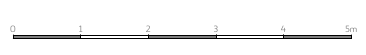 If a 5 cm bar is labeled “5 m,” it means 5 cm on the map equals 5 meters (16.4 feet) in reality.
Maps use larger scales (e.g., 1:50,000) for broad regions like countries and smaller ones (e.g., 1:100) for detailed city layouts. Knowing how to interpret these helps you figure out real distances—like the actual trek from point A to point B.
Model Scale: Crafting Realistic Miniatures
In modeling—think cars, planes, or trains—scale indicates how many times a model has been reduced (or rarely, enlarged) compared to its real-life version. It’s usually expressed as a ratio, like 1:24 or 1/72. For instance:
- A 1:24 scale car means 1 cm (or 1 inch) on the model equals 24 cm (or 24 inches) on the actual car.
- A real car 4.8 m (15.75 ft) long shrinks to 20 cm (7.9 in) at 1:24 scale.
Certain scales have become industry standards. In airplane modeling, 1:72 and 1:48 are favorites, while railway modeling uses lettered scales:
- Z scale: 1:220 (perfect for tiny trains in small spaces).
- TT scale: 1:120 (a hit in Europe).
- HO scale: 1:87 (the global go-to for train enthusiasts).
These standard scales allow collectors to create displays—like a squadron of planes or a miniature rail village—that look cohesive and true-to-life on a shelf or tabletop.
Project Scale: Turning Plans into Reality
In architecture and engineering, a project refers to technical drawings or blueprints that guide construction. These rely on scales like 1:100 or 1:200 to fit real-world dimensions onto paper. For example:
- At 1:100 scale, 1 cm (or 1 inch) on the plan equals 1 m (or 100 inches, about 8.33 ft) in reality.
- A 10 m (32.8 ft) wall becomes 10 cm (3.94 in) on the blueprint.
Project scales are vital for accuracy. Builders depend on them to measure everything—walls, doors, roofs—ensuring the final structure matches the vision. A tiny misstep in reading the scale could lead to a major error on-site, so precision is non-negotiable.
Why Scale Matters
Whether you’re navigating with a map, piecing together a model, or sketching a building, scale connects the dots between concept and reality. It’s a universal tool that turns complex dimensions into something manageable. And with resources like our https://calculatescale.com, you can effortlessly switch between scales and units—metric or imperial—without breaking a sweat over calculations.
Ready to give it a go? Grab a model or map, pick a scale, and see how it lines up with the real world. You’ll be surprised how this simple ratio deepens your grasp of proportions. Try our scale calculator and unlock a new perspective today!